Réseau express vélo

Montreal's Express Bike Network, known by its french acronym
Réseau Express Vélo (REV), has been in the planning phase for the past
couple of years. Recently, the Covid crisis has highlighted the sudden
need for social distancing and portions of the REV network have been
quickly implemented by the city.
Apparently the Christophe Colomb path is not considered part of the REV but rather part of the overall Covid response. What distinction this makes in terms of street design is unclear. An outline of what is included with the REV project can be found here.
The following map
shows where the city's plans to implement changes to street design as
result of new need for social distancing in the near future. The press release from the city can be found here.

The first changed path that I noticed was the Rachel / Sherbrooke path between Parc La Fontaine and Viau Street. The second was Avenue Christophe Colomb between Parc Wilfrid Laurier and the north shore of the island bounded by the Rivière-des-Prairies. Both of these new paths greatly improve both the capacity and safety over the previous street design.
Overview of the paths within the Quebec Bicycle Network
These two first two implementations of post Covid bike path modifications are on some of the most highly used and oldest portions of the overall Route Verte bicycle highway system within the province of Quebec. The Rachel / Sherbrooke path heads east eventually linking with Route 5 leading along the North Shore of the St Lawrence to Quebec City. The Christophe Colomb path is part of Route 1 which leads north to the Parc Linéaire Le P'tit Train du Nord. The separated portion of the Route 1 bike path eventually ending at the town of Mont Laurier approx 300 km away from Montreal. The Velo Quebec headquarters are located at the junction of Route Verte 1 and the Rachel bicycle paths.
Rachel / Sherbrooke Street Path
Using the Velo Quebec Headquarters as a starting point, heading east, the Rachel path is a separated bi-directional path. My guess is that this portion was first built in the 1970's. This portion of the path is among the most heavily used in the city and has not been modified since the Covid crisis.
 |
| Rachel Path near Parc La Fontaine |
East of Parc La Fontaine a second path has recently been added to original path on the opposite side of Rachel. I'm not certain if the second path is for social distancing of pedestrians or for east bound bicycles.
 |
| Original path with second path added on far side of Rachel |
 |
| Further east, some of the modifications involve both Social Distancing and bike path expansion |
 |
| Rachel approaching the Olympic Stadium, original path on left now has doubled capacity |
 |
| Sherbrooke Street beside the Olympic Stadium. New bike path added on street beside the original located beside the street on the right. |
Route Verte #1 (Christophe Colomb) path
Again using the Velo Quebec Headquarters as a starting point, heading north, the Route Verte #1 path is a bi-directional path separated from traffic by parked cars. South of Parc Wilfrid Laurier the path runs on Brebeuf street. It is unchanged since the start of the Covid crisis.
 |
| Route Verte # 1 South of Parc Wilfrid Laurier. Unchanged since Covid crisis began. |
 |
| Two new South bound bike lanes on Christophe Colomb. The two new North bound lanes on on the far side of the street. |


Between Jarry and Sauvé Route Verte #1 bike path ran along grassland west of Christophe Colomb. The two new unidirectional paths have been added on both sides of the street similar to the portion of the street further south.
 |
| New South bound path on Christophe Colomb, original bidirectional path is on right behind grass hill. New North bound lanes are on far side of street. |
 |
| In this portion the original bidirectional path is above the curb on the right. New North bound lanes are on far side of street. |
Between Sauvé and the Rivière-des-Prairies the original bidirectional path was located on the west side of Christophe Colomb. This original path is now the South bound lanes and the new North bound lanes have been built on the far side of the street.
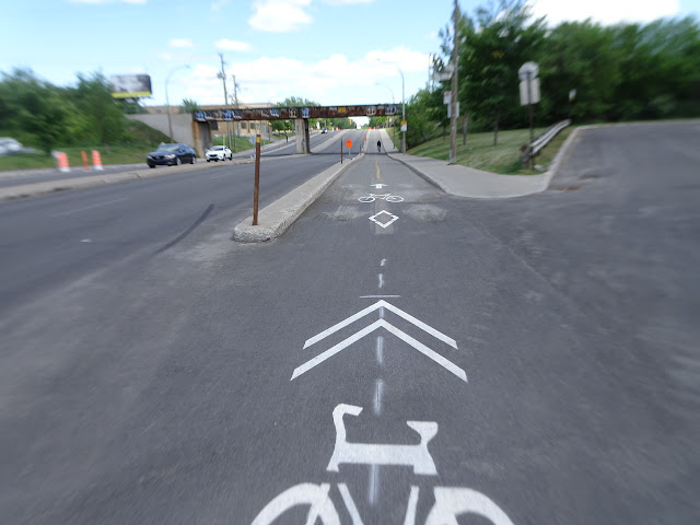 |
| South bound lanes on original path, new North bound lanes on far side of street. |
Summary
The new REV style unidirectional paths on both sides of the street represent a major upgrade to the traditional bidirectional bike paths seen in most of Montreal. Bravo to the city for taking this important step.
Thanks A.T., very good description of multiple changes. Pleased to see Montreal turning the virus crisis to some good. It will be interesting to see how these changes increase the cycling ridership. The sharing of the cycling lane with turning cars bothers me. Intersections need to be hyper secure, especially for new urban cyclists. I had read somewhere that the REV was supposed to have traffic lights coordination for free flowing cycling. As the block lengths in that area seemed to be rather equal, I suppose it would be possible both for north cycling and south cycling.
ReplyDeleteDan tells me that the hatched areas near intersections are for bus stops, not for right turning cars. During the ride I didn't see any buses at the stops but I did see multiple right turning cars.
ReplyDelete